The Northern Circuit
The Northern Circuit
Why Should You Climb
The Northern Circuit Route?
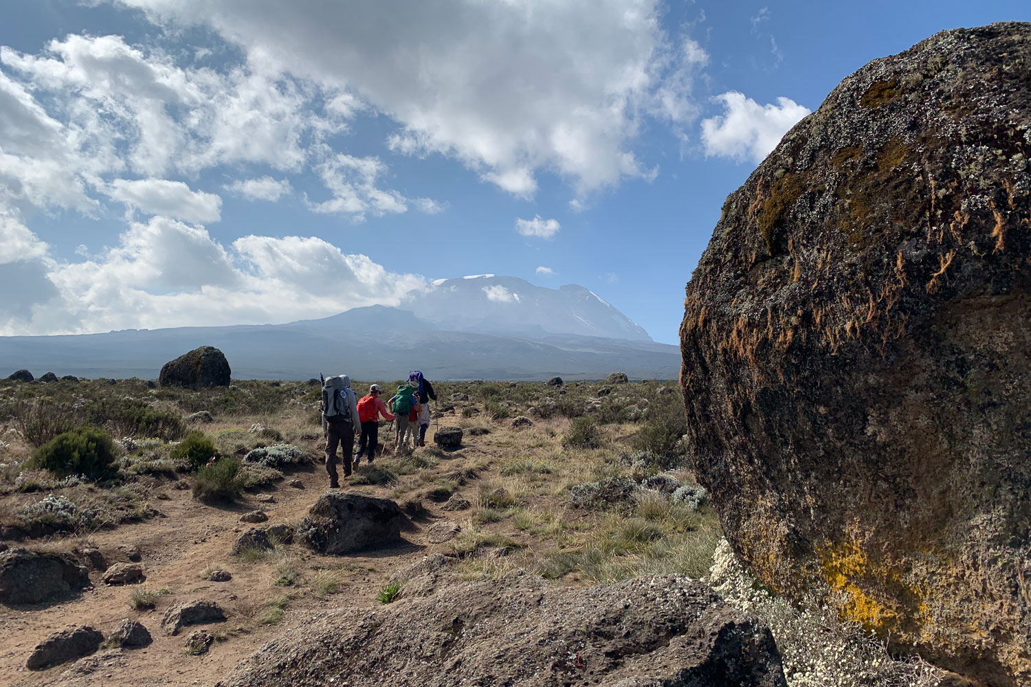
The Northern Circuit is the longest route on Kilimanjaro, offering nearly 360 degrees of beautiful scenery.
Why Should You Climb
The Northern Circuit Route?
The Northern Circuit is the longest route on Kilimanjaro, offering nearly 360 degrees of beautiful scenery.
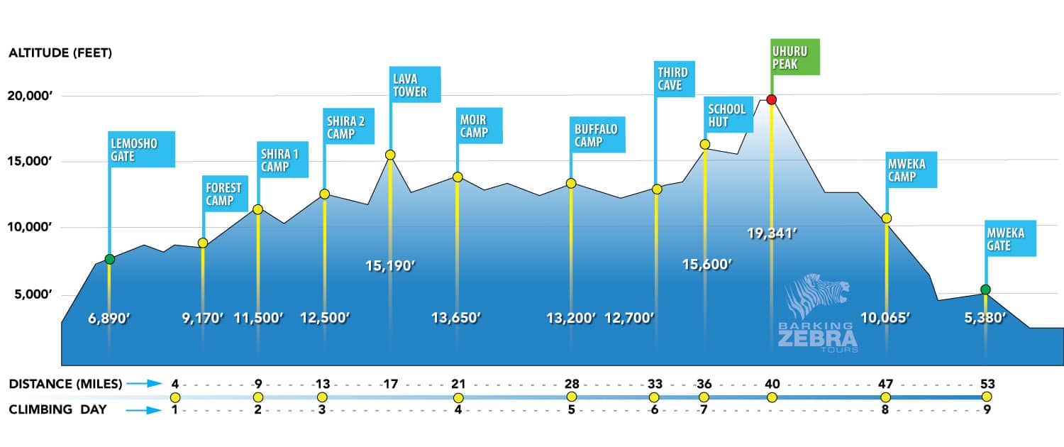
Northern Circuit Route Elevations
Northern Circuit 9-Day Itinerary
Elevation
Londorossi Gate: 6,890 ft | 2,100 m
Forest Camp: 9,170 ft | 2,795 m
Hours of trekking: 3-4
Habitat: Rainforest
Meals: B/L/D
After breakfast, we depart to the western side of the Kilimanjaro National Park to Lemosho gate and complete registration formality. Our trek today will be an easy walk up a small path through beautiful and rain forest. Our first camp is located in the rain forest. Look out for black and white Colobus monkeys in the lush tree canopy.

Elevation: 11,500 ft | 3,505 m
Hours of trekking: 4-6
Habitat: Moorland
Meals: B/L/D
This morning we leave the glades and start trekking towards the moorland zone and Shira Caldera, which is a high altitude desert plateau. Shira Plateau shows the remains of an ancient caldera, a volcanic crater that expired around half a million years ago. Today, it stands as a World Heritage Site, boasting deep valleys and weather-beaten lava flows. We will get our first close views of Kibo – the summit of Kilimanjaro.

Elevation: 12,500 ft | 3,810 m
Hours of trekking: 3-4
Habitat: Moorland
Meals: B/L/D
Today we explore the grassy moorland and volcanic rock formations of the plateau. We take a short hike to the summit of awe-inspiring Shira Cathedral, one of the most amazing natural landmarks on Kilimanjaro. The heath zone displays abundant wildflowers and unique Senecio trees. From our camp, we take in the unforgettable views of Mt. Meru as she floats among the clouds. This is a relatively short day but an important day in terms of rest and acclimatization.

Elevation: 13,650 ft | 4,160 m
Hours of trekking: 5-7
Habitat: Alpine Desert
Meals: B/L/D
Today we hike east across the Shira Plateau, one of the highest plateaus on earth. We have lunch at Lava Tower at 15,190 ft /4,630 m to help our bodies acclimatize to the thin air. Then we continue to Moir Hut, a quiet site on the base of Lent Hills. A variety of walks are available on Lent Hills, making this an excellent acclimatization opportunity.

Elevation: 13,200 ft | 4,023 m
Hours of trekking: 5-7
Habitat: Alpine Desert
Meals: B/L/D
We climb out of the Moir Valley and take a short detour to reach the summit of Lent Hills (15,400 ft |4,693 m) before returning to the main trail. The final section of today’s walk undulates until reaching our camp. At the camp, there is a huge feeling of space as the Kenyan plains stretch out far below to the north.

Elevation: 12,700 ft | 3,870 m
Hours of trekking: 5-7
Habitat: Moorland
Meals: B/L/D
From Buffalo Camp, we climb to the top of ‘Buffalo Ridge’ and cross numerous ridges and gullies. This route is rarely traveled, and we will enjoy its mountain wilderness. The trail continues eastwards through a landscape that has increasingly sparse vegetation until we reach our camp

Elevation: 15,600 ft | 4,750 m
Hours of trekking: 4-5
Habitat: Alpine Desert
Meals: B/L/D
There is a steady ascent to reach the saddle, a lunar landscape between the peaks of Kibo and Mawenzi. From here, we continue upwards and reach our camp in the early afternoon. The remainder of the afternoon is spent resting and preparing for the summit push.

Elevation Uhuru Peak: 19,341 ft | 5,895 m
Hours of trekking to Uhuru Peak: 6-8
Habitat: Arctic
Elevation Mweka Camp: 10,065 ft | 3,067 m
Hours of trekking to Mweka Camp: 5-6
Habitat: Heath
Meals: B/L/D
We’ll be up before midnight to set out for the glacier zone atop Kilimanjaro. Walk slowly, drink plenty of water and refuel with small snacks to keep our energy high. We rest for a short time at Gilman’s Point (18,600 ft) to enjoy the spectacular sunrise over Mawenzi.
We celebrate our success with a few quick pictures at the top before before descending to Barafu camp for lunch and a short rest. Gaiters and trekking poles come in handy for the loose gravel going down.
Mweka Camp is situated in the upper forest and mist or rain can be expected in the late afternoon.

Elevation: 5,380 ft | 1,640 m
Hours of trekking: 3-4
Habitat: Rainforest
Meals: B/L
Celebrate your achievement with your mountain crew and partake in a tipping ceremony to thank your guides and porters, acknowledging their hard work and contribution to your success.
Descend back through the rainforest and enjoy a farewell lunch with your group at the Mweka gate.

Private Climbs
Let us build the Kilimanjaro climb that is perfect for you.
